How Florida Got Its Shape
Osher Lifelong Learning Institute (OLLI) presents How Florida Got Its Shape.
$15 per person
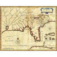
Of the 50 states, Florida has one of the most distinctive and widely recognized shapes. But how did that familiar shape come to exist? Obviously, the state's 1,350-mile coastline defines the majority of it, but what about its borders to the north and west? It might surprise you to learn that “Florida” has, at various times, stretched as far north as present-day Virginia and as far west as the Mississippi River. Florida’s current shape was settled during a fascinating era before the region was a U.S. state. In those days, Florida was an international borderland.
Join us for a brief journey into that era - illustrated with maps and records explaining exactly how and why Florida acquired its well-known shape.

Date and Time
Tuesday Jun 3, 2025
11:00 AM - 12:00 PM EDT
Website
Contact Information
941-309-5111
Send Email
